Research Vessel OverviewR/V ISABU
“Isabu” was named after General Isabu of the Silla Dynasty, who conquedred the nation of Usan-guk, which occupied present-day Ulleungdo Island, and incorporated it into Korea. This name was given to the research vessel to signify KIOST’s adventurous spirit, akin to that of General Isabu, and dedication to expanding its influence in the area of marine science in order to help Korea become a leader in the global maritime community.
Contact Information
- Fax001-870-783-112-511
- Port
- Mobile010-4435-1055
- E-mailisabu@sea-one.com
inmarsat
- 001-870-773-111-189
- 070-4296-2496
R/V IsabuVessel Information
- Full length 99.8m
- Width 18.0m
- International gross tonnage 5,894t
- Speed 12 knots (cruise),15 knots (maximum)
- Range 10,000miles
- Passenger capacity 60Researcher 22, Crewman 38
R/V IsabuNavigation and Communication Equipment

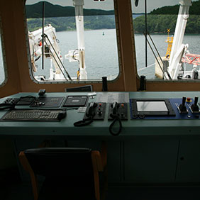
The room from which the crew supervises and guides the operation of the ship.

A device that ensures the research vessel maintains its position so that researchers may conduct their research, even in poor weather, using ROV or exploration equipment 6,000 meters underwater.
The system consists of two main propellers at the stern of the vessel, a pump-jet thruster, a retractable thruster at the bow, a DGPS system, and three types of sensors for measuring wind direction, wind velocity, and the movement of the vessel.

The research vessel acquires information on its position using DGPS (Differential GPS), which is accurate to within one meter. The navigation system employs the pseudorange correction method, in which distance errors are detected and corrected to estimate the position of the vessel, using time and orbital data communicated via satellite from the reference station.
During navigation or exploration, this system guides the research vessel to the exploration site. The mounted equipment then links the vessel’s position to motion sensors and contributes to enhancing the accuracy of the observed positioning data by correcting for the differences in positioning information from three-dimensional coordinates and positioning data that have been precisely measured on land in advance.
An all-weather global positioning system that provides highly accurate locational information, this system allows the vessel to determine its position anywhere in the world.

A system that detects and locates an object by emitting radio waves toward and receiving radio waves from the object.

Satellite communication refers to communication or other transmissions of media conducted via satellites deployed at certain orbital altitudes. On research vessels, satellite communication equipment provides communication and weather information necessary for navigation.

A device for receiving weather information necessary for navigation while a vessel is at sea.

A device that measures the speed of a vehicle. On vessels, speedometers measure and indicate the speed of the vessel relative to the water.

A tracking system that automatically locates and identifies other vessels.

An information system that allows for the easy and prompt recognition of the geography of the surrounding area and indicates the vessel’s position on an electric chart, which has replaced paper charts.

An instrument capable of measuring the depth of water while a vessel is stationary or in motion.

A GPS and motion system that provides accurate, real-time locational information for the research vessel and the mounted research equipment it operates. It also corrects the vessel’s attitude data. For higher accuracy, the system uses DGPS (Differential Global Positioning System), based on which it receives GPS signals from satellites and signals from groundbased reference stations through beacon receivers, allowing for the correction of positioning errors.
R/V IsabuResearch Equipment

Devices that emit sound waves from a blister-type acoustic sensor mounted on the bottom of the vessel as a means of observing and recording water depth and the geography of the seabed. Unlike single-beam echo sounders, which can take measurements at only a single location immediately below the vessel, multibeam echo sounders produce a swath of depth measurements and readings within the sound wave emission and reception range of the device. The information collected by the multibeam echo sounder is transmitted to a computer onboard the vessel, which then produces a bathymetric map or a contour map with relevant colors and graphics in real time. The data gained from each ping is separated into different types of information, and the device can take measurements down to a depth of 11,000 meters underwater.
- Real-time measurement of water depth and submarine topography and vessel motion correction
- Capable of data storage and concurrent sharing (broadcasting) of RS-232 communication usage data
-
EM 122
- Transducer: 1°×1°; Maximum coverage: approx. 30,000 meters,
- Depth Range : 20 to 11,000m
-
EM 710
- Transducer: 0.5°×1°, Maximum coverage: approx. 2,400 meters,
- Depth Range : 0 to 2,000m

A device that emits and receives sound waves in order to accurately calculate the distance to the ocean floor.
- 12, 38, and 200 kilohertz
- Resolution : 1cm
- Depth Range : 5m to 10,000m
- Accuracy : 12Khz / 20cm, 38khz / 5cm, 200khz / 1cm

A device that measures the force of gravity using elastic deformation. Generally, an air-sea gravity meter is able to take measurements that are accurate to within 1/100 of a milligal. There are two different types of such gravity meters—spring-based meters, which use elastic springs with weights, and dynamic gravity meters, which use elastic vibration. Marine gravity meters are used to measure gravity on vessels at sea. These meters are equipped with anti-shock instruments on the four corners of the device to minimize the influence of the motion of the vessel.
- Resolution 0.01 mGal
- Static Repeatability 0.05 mGal
- Accuracy At Sea 1.0 mGal
- Platform range : 25° of roll and 22° pitch
- Platform Period 4 Minutes
- Platform Damping 0.707 of critical damping
- Drift : 3.0 mGal

A device that measures the velocity and volume of ocean currents over a range of depths using the fact that changes occur in the frequency of a sound wave produced by a moving source, known as the Doppler effect. The profiler operates at the frequency bands of 38 and 150 kilohertz, which are effective at depths of up to 1,000 and 400 meters, respectively.
- Measures the horizontal and vertical velocity and direction of water flow at different depths
- Communications: RS-232 or RS-422. hex ASCII or binary output at 1,200∼115,400 baud.
- Velocity long-term accuracy(typical) : ±1.0%, ±5 mm/s
- Velocity range: -5 to 9 m/s
- Number of depth cells: 1-128
-
OS 38
- Water profile (Maximum) : 1,000m
- Max ping rate: 38kHz(0.4Hz)
- Bottom track Maximum altitude(precision < 2 cm/s) : 1700m
-
OS 150
- Water profiler (Maximum) : 400m
- Max ping rate: 150kHz(1.5 Hz)
- Bottom track Maximum altitude(precision < 2 cm/s): 600 m

A comprehensive oceanographic observation device designed to measure the basic physical parameters of conductivity, temperature, and depth using an overhead crane or winch on the vessel. The device transforms analog signals from CTD sensors into digital data and uses single-conductor cables to read and store the data in real time on the research vessel. Optional sensors, such as a transmissometer, fluorometer, PAR (irradiance) sensor, or altimeter, are also mounted on the device, which can collect seawater samples in 36 12-liter Niskin bottles.
-
Measurement Range
- Temperature : -5 to +35 °C
- Conductivity : 0 to 7 S/m
- Pressure : 0 to 1400/2000/4200/6800/10500 meters
-
Initial Accuracy
- Temperature : 0.001 °C
- Conductivity : 0.0003 S/m
- Pressure : 0.015% of full scale range

A device used to acquire high-resolution images and data on multiple layers of sediment and rock under the seafloor. The profiler emits sound waves with a frequency range of two to seven kilohertz, processes the signal reflected back from the ocean floor and sub-bottom layers of the ocean floor, and provides information on the strata of the ocean floor. This device is especially useful for surveying sub-bottom layers of the ocean floor in preparation for the construction of cross-sea bridges or offshore structures and the installation of submarine cables.
- Signal source : Parametric source level generation
- Using Frequency : Primary : 18 - 33 kHz, Secondary : 0.5 kHz - 6 kHz
- Penetration range : Up to > 200 m(approx.)
- Power consumption : < 2.7kW(approx)
- Beam width : 4.5°x 5.0°
- Depth range : 10 m –11,000 m
- Pulse length : 0.33 - 25 ms
- Resolution : 6 cm
- Sediment penetration : 15cm
- Pulse type : Continuous wave(CW),Chirp (frequencymodulated),Barker-coded(11 bit)

These are bioacoustic devices that form a system for measuring the distribution of marine organisms. The devices are installed on the drop keel and are used to perform threedimensional, broad area surveys of eggscatterers and marine organism distribution, conduct surveys of the distribution and movement of biomass resources, and study the characteristics of species distribution.
-
EK 60 (Frequencies 18, 38, 70, 120, 200, 333 kHz)
- Two-dimensional, continuous exploration of the spatial and temporal structure of marine organisms (zooplankton, fish larvae, fish, etc.)
- Quantification of distribution density using acoustic data
- Separation of dominant species using multi-frequency acoustic data
-
ME 70 (Scientific Multi-beam system / Frequency 70 to 120 kHz )
- Concurrent, precise measurement of submarine topography and species distribution
- Separation of species using multi-frequency system
- Three-dimensional, broad area survey of species distribution
-
SH 90 (360° Omnidirectional sonar / 90° Vertical tip / Frequency 114 kHz)
- Exploration of the spatial and temporal structure of marine organisms
- Measurement of biodiversity in 360-degree area surrounding the research vessel (Range: 50 to 2,000 meters)
- Broad area survey of species distribution

A relatively simple device that continuously observes the temperature, salinity, and pCO2 of surface water while the research vessel is in motion. The temperature sensor is installed in the clean sea water pump room, and the device consists of a wet box and dry box.
-
NDIR(Non-Dispersive Infrared) Analyze
- Range: 0 to 3000 μmol/mol, Accuracy: 1% nominal
- Zero Drift (with temperature) : < 0.1 μmol/mol/℃
- Water Sensitivity: < 0.1 μmol/mol CO2/mmol/mol H2O
-
Temperature
- Range : -3 to 50 Deg.C , Accuracy : 0.003 Deg.C
- Resolution : 0.0002 Deg.
-
Conductivity
- Range : 0 to 7 mS/cm , Accuracy : 0.003 mS/cm
- Resolution : 0.0003 mS/cm

A device used to calibrate the various acoustic sensors installed on the bottom of the research vessel in the event of drastic changes in the sound velocity or temperature of surface water while the research vessel is in motion. This process involves the research vessel lowering a probe into the water to measure sound velocity at different depths and calibrate each acoustic sensor. The XBT is composed of a probe, launcher, data acquisition and processing devices, and a controller.
-
Probe
- Measurement point: Starboard and port are both possible
- XBT : Temperature resolution 0.01℃, Range –2 to 35℃

A device that measures sound velocity using a sound velocity sensor mounted on the bottom of the vessel and automatically sends the measured values to acoustic sensors for the purpose of calibration while the vessel is in motion. When the vessel is stationery, a sound velocity profiler is used to measure the sound velocity of each water layer and store the data, which can then be downloaded to a computer using dedicated software. The data thus acquired are processed and used to correct observed data from various acoustic devices, such as multibeam and other types of echo sounders.
-
Probe
- Measurement point : 6.5m
- Range 1375 to 1625 m/s, Precision ±0.006m/s, Accuracy ±0.025m/s
-
Profiler
- Operating depth Range : 0 ∼ 6,000m
- Range 1375 to 1625 m/s, Precision ±0.006m/s, Accuracy ±0.025m/s

A system that provides all information necessary for the navigation and exploration activities of the vessel, such as information on the vessel’s movement, navigation, operation of exploration equipment, onboard network, and all other information related to the operation of the research vessel. The system increases the vessels efficiency and capability to conduct comprehensive research and observations, as it shares and distributes information among researchers onboard, provides assistance in relation to ocean research activities, and collects important observational data, analyzes and displays the data on monitors, stores the data, and transmits the data to other research equipment and devices.
- Draw up and revise preliminary exploration plan for the research site
- Schematize data: provision of information on the location of the vessel and operation of winches, correction of positional and observational data, and sharing of exploration data

A GPS and motion system that provides accurate, real-time location information for the research vessel and the mounted research equipment it operates. It also corrects the attitude data of the vessel. To increase the accuracy of the vessel’s position based on a ground-based reference point, the device uses DGPS (Differential Global Positioning System) and dedicated antennae to receive GPS signals. The device receives DGPS signals in real time and transmits those signals to each piece of research equipment.
-
C-NAVE 3050
- Accuracy : Horizontal : < 10cm, Vertical : < 15cm
- Multi-constellation support and tracks GPS, GLONASS, Galileo, C-Nav, other SBAS (WAAS/EGNOS) signals, and accepts external RTCM input.
- 66-channel combined GPS/GNSS/L-band receiver provides sub-meter.
-
SeaSTAR 9205 G2 Receiver
- Accuracy : Horizontal : 10cm(95%), Vertical : 15cm(95%)
- Channels ; 72-channels, GPS - L1 C/A code, GPS - L1/L2/L2C Full cycle Carrier, GLONASS - L1/L2 Full Cycle Carrier. SBAS (WAAS/EGNOS/MSAS), Fugro L-Band service
-
Seapath 330+
- Position Accuracy(X and Y) : 1cm+1.6ppm RMS, Accuracy (Z) : 2cm+3.2ppm RMS

A device that measures the vessel’s heading, roll, pitch, heave, and other data to allow the operation of the dynamic positioning system (DPS) and provides position and attitude information to equipment that requires corrections for the motion of the vessel.
-
PHIN
- Heading, Motion data (Pitch, Roll, Heave)
- Heading Accuracy : 0.01° (secand latitude)
- Roll and pitch accuracy : 0.01°
- Position Accuracy : 2 to 5cm w/RTK DGPS or 0.5 to 3m w/DGPS
- Position accuracy : 20 m in no aiding for 5 minutes
-
Seapath 330+ (with MRU5+)
- Heading Accuracy : 0.04° RMS(4M baseline)
- Roll and Pitch Accuracy : 0.01° RMS for ±5° amplitude
- Heave accuracy : 5cm or 5% whichever is highest

A positioning system that uses USBL/LBL to track the position of underwater vessels, such as an ROV (remotely operated underwater vehicle) or other exploration devices, and allows the DPS to maintain its position.
- Operating Range : 1-10,000m
- Positioning accuracy in % of Range : 0.2%
- Operating beam : 120°
- Receiver frequency band : 13.0 ~ 15.5 Khz
- Telemetry frequency band : 12.0 ~ 13.0 Khz
- Transmiter frequency band : 10.0 ~ 12.5 Khz

A system designed to collect, store, and display real-time meteorological data needed for navigation and research purposes.

A room located in the central part of the research vessel from which all of the winches are operated. All winches onboard the vessel, except for the CTD (conductivity, temperature, and depth) winch, are installed and operated from the winch room. Through the cable trunk, winch cables are operated by the starboard and stern A-frames, thereby allowing for the efficient support and use of research equipment.
Large devices and equipment used in ocean exploration, such as an ROV, deep sea cameras, or MOCNESS, are connected to winch cables and lowered or raised to specific depths as needed. Devices used to observe the marine environment and collect samples of benthic organisms and mineral resources can also be attached to the winch cables.
- Wire deployment & recovery speed controllable between 0 and ≥ 100m/min
-
Deep Tow Winch #1
- Cable length: approx. 10,000m, Cable size: Ø18 mm
- Cable spec.: Optical 3, Power 3
-
Deep Tow Winch #2
- Cable length: approx. 10,000m, Cable size: Ø18 mm
- Cable spec.: Optical 1, Conductor 2
-
Traction Winch for Deep Tow Winch
- Type : ELECTRIC WINCH
- Safety Working Load(SWL) : 20t
-
CTD winch #1
- Instrument Mass with full 12 lire sampling bottles on a 36 bottle rosette and ancillary instruments up to 1 ton
- Maximum cast depth: approx. 6000 m
- Cable length: approx. 10,000 m, Cable size: Ø11.43 mm
- Cable spec.: Coaxial gal’v cable
-
General purpose Winch
- Cable length: approx. 10,000 m, Cable size: approx. Ø20 mm
- Cable type: Steel wire (anti twist)
-
GPC winch
- Application : Giant piston Corer
- Cable length: approx. 10,000 m, Cable size: Ø 28 mm
- Cable spec.: Synthetic rope
-
Traction WINCH FOR CORING WINCH
- Type : ELECTRIC WINCH
- Safety Working Load(SWL) : 20t
-
General purpose Winch
- Cable length: approx. 10,000 m, Cable size: approx. Ø20 mm
- Cable type: Steel wire (anti twist)

Provides real-time data on the orientation, attitude, and position of the vessel. Corrects the position and attitude of acoustic equipment.

For measuring the salinity of seawater.

A device used to synchronize acoustic equipment.

A time synchronization device. 1. Manufacturer: Microsemi (USA) 2. NTP Server Model: Sync Server S250 3. Caesium Atomic Clock Model: CSIII 4. 1PPS Distribution Amplifier Model: 4033A

An air compressor that forms part of a seismic system designed to survey the layers of the ocean floor.

Installed on the starboard side of the vessel, this is a system through which a corer handler is used to lower a piston corer to collect cylinders of sedimentary layers from as deep as 30 meters below the ocean floor.
- Maximum Corer Length : 30m(5×6m Corer barrels)
- Barrel Diameter : 140mm
- Internal Corer diameter : 100mm
- Trigger corer length : 2m
- GPC Weight : Approx. 5,990kg
- Cradle Weight : Approx. 3,000kg

This is a system that allows researchers to observe sedimentary deposits, hydrothermal sediments, and biological specimens on the ocean floor, thousands of meters below the water’s surface, and collect samples using a very small, video-guided, metal-frame grab.
- Sampler controller: Hydraulic-powered grab or other device
- Monitoring of ocean-floor sample collection: Xenon light and color video camera
- Operational depth: 6,000 meters

MOCNESS uses several nets to collect zooplankton at different depths and is equipped with sensors for detecting water temperature, salinity, and other marine characteristics, allowing researchers to collect zooplankton and make observations of the marine environment simultaneously.
- Opening Size of Net : 1 square meter, Net Size : 333 micron mesh
- Depth rating : 6,000m(10,000 psi or more)
-
Conductivity Sensor
- Measurement Range : 0.0 to 7.0 S/m
- Initial Accuracy : 0.0003 S/m
- Resolution : 0.00004 S/m at 24Hz
-
Temperature Sensor
- Measurement Range : -5.0 to +35 ℃
- Resolution : 0.0003℃ at 24 samples per second
- Initial Accuracy : ±0.001℃

This is a device used to collect fish eggs while the vessel is in motion. It permits water of up to three meters in depth to enter the vessel, filters fish eggs and particles of certain sizes (approx. 500 microns), and then discharges the water outside the vessel. The filtered fish eggs and particles are transported to and stored in a sampler.
-
Concentrator
- Height x Width x Length: 81.2 x 30 x 61 centimeters
- Weight: 60 kilograms
- Material: Aluminum (hard anodized)
-
Sample collector
- Height x Width x Length: 60.96 x 33.02 x 43.18 centimeters
- Weight: 19 kilograms
- Frame material: Aluminum (hard anodized)
- Tank material: Polyethylene

A device for measuring the height of waves. Installed on the research vessel, WAVEX is a type of wavemeter used for observing waves in the waters surrounding the vessel. Wave data obtained from the wavemeter is used as base data for navigation purposes as well as for determining the feasibility of operating different pieces of ocean-observation equipment.
-
Significant wave height
- Range : 0 – 5 m : Resolution : 0.1 m Std. dev. : 0.5 m
- Range : 5 – 10 m : Resolution : 0.1 m Std. dev. : < 10%
- Range : 10 – 15 m : Resolution : 0.1 m Std. dev. : < 20%
-
Wave period
- Range : 5.0 – 13.0 s : Resolution : 0.1 s Std. dev. : < 10%
- Range : 3.2 – 5.0 s : Resolution : 0.1 s: Std. dev. : < 20%
- Range : 13.0 – 25.6 s : Resolution : 0.1 s Std. dev. : < 20%
-
ave direction
- Range : 1 – 360 °, Resolution : 1 °, Std. dev. : < 20 °
- Wind speed for operating : 2 m/s

A device for receiving real-time meteorological data. A system that receives and processes real-time meteorological data from meteorological satellites (NOAA and METOP satellites) while the vessel is in motion. The processed data is used for vessel operation and research purposes.
- Radome : Attenuation Less than 0.15dB at 1.7GHz Transmission & Scattering.
-
Reflector
- Material : Solid Aluminum, Size : 1.5m
- Surface Tolerance : More than 0.02 inches.
-
L-Band Feed
- L-Band Input Frequency : 1670 ~ 1720 MHz Minimum.
- VSWR : 1.5:1 ratio Maximum.
- Axial Ratio : 2.0dB Maximum at 1700 MHz and 2250 MHz

A system that uses ultraclean technology to collect samples of trace elements and isotopes for analysis.
The TEI Ultraclean Sampling System is used to collect seawater from depths of up to 6,000 meters. The characteristics of the collected seawater are observed for the study global environmental changes and changes in the marine environment as well as to gain an understanding of the marine ecosystem through research on the global distribution and circulation cycle of trace elements and isotopes in the oceans.
This system consists of a water sampling system for collecting seawater and an ultraclean laboratory container for storing the collected seawater and protecting it from contamination.
- NIOZ UHP PVDF butterfly valve bottles 26 pieces (2 spares) / 12 liter volume
- Ultra High Purity PVDF material
- CTD-frame : full titanium for contamination free, 6,000m
- CTD system (Seabird SBE 9 plus) c/w MCBH- connectors, titanium casing
- Transport system : aluminium transport pallet, stainless steel strengtened pallet trolley
-
Clean Room Container : standard 20ft or High cube 20ft container
- Air Conditioning : 3 stage filter : G4, F9, H13
- Max. amount of air : 2,000m3/h
- maintained over pressure : 15Pa
R/V IsabuResearch Support Equipment

This device is connected to a winch cable used for lowering large pieces of research equipment down to specific depths for the collection of benthic organisms and mineral resources. Featuring an optical winch cable, the winch can accommodate large research devices that require the use optical and electronic signals, such as deep-sea cameras, deep seafloor side-scan sonar, movable Toyo-CTDs, unmanned submarine systems, etc.).
-
Deep Tow Winch #1
- Application : Multi layer plankton sampler, Towed CTD others
- Cable length: approx. 10,000m, Cable size: Ø17.27mm
- Cable spec.: Optical 1, Conductor 2
- Wire deployment & recovery speed controllable between 0 and ≥ 100m/min
- Traction winch capacity: Ø18 mm
- Safety Working Load(SWL) : 2t
- Slip ring : Focal 180 - Four pass
-
Deep Tow Winch #2
- Application : Deep towed side scan sonar, Deep Camera, ROV, TV Grab, others
- Cable length: approx. 10,000m, Cable size: Ø17.35mm
- Cable spec.: Optical 3, Power 3
- Wire deployment & recovery speed controllable between 0 and ≥ 100m/min
- Traction winch capacity: Ø18 mm
- Safety Working Load(SWL) : 2t
- Slip ring : Focal 180 - Four pass
-
Traction Winch for Deep Tow Winch
- Type : ELECTRIC WINCH
- Safety Working Load(SWL) : 20t

This winch comes in two types—one for general CTDs and one for metal-free and ultrapure CTDs. It features 10,000 meters of CTD cable for lowering and raising CTD devices to and from the ocean floor.
-
CTD winch #1
- Instrument Mass with full 12 lire sampling bottles on a 36 bottle rosette and ancillary instruments up to 1 ton
- Maximum cast depth: approx. 6000 m
- Cable length: approx. 10,000 m, Cable size: Ø11.43 mm
- Safety Working Load(SWL) : 8t
- Cable spec.: Coaxial gal’v cable
-
CTD winch #2
- nstrument Mass with full 12 lire sampling bottles on a 24 bottle rosette and ancillary instruments up to 1 ton
- aximum cast depth: approx. 6000 m
- able length: approx. 10,000 m, Cable size: Ø15.25 mm
- afety Working Load(SWL) : 5t
- able spec.: Synthetic EM cable,
-
CTD overhead Crane
- Type : HYDRAULIC OVERHEAD CRANE
- Vertical LOAD : 6 Tons (SWL)
- Trolly Speed : 0-12m/min
- Tilting Time Up/Down : 20 s / 20 s
- Telescopic Time Out/In : 25 s / 25 s
- Max. Outboard reach : 3000mm
-
General purpose Winch
- Application: Dredge bucket, Multi core sampler, Box corer, Pinger(USBL), Coring others
- Cable length: approx. 10,000 m, Cable size: approx. Ø20 mm
- Cable type: Steel wire (anti twist)
- Safety Working Load(SWL) : 20t
- Wire deployment & recovery speed controllable between 0 and ≥ 100m/min
-
General purpose winch (portable)
- Application: Bonge net, Universal conter, CTD others
- Maximum cast depth: approx. 6000 m
- Cable length: approx. 6,000 m, Cable size: Ø8.03 mm
- Cable spec.: Coaxial gal’v cable
-
GPC winch
- Application : Giant piston Corer
- Cable length: approx. 10,000 m, Cable size: Ø 28 mm
- Safety Working Load(SWL) : 6t
- Cable spec.: Synthetic rope
-
Traction WINCH FOR CORING WINCH
- Type : ELECTRIC WINCH
- Safety Working Load(SWL) : 20t
-
Corer winch (Hydraulic)
- SAFETY WORKING LOAD : 9 Ton
- Max. Heel/Trim : 11〬〬 / 3〬
- Angle of lifting : 54〬〬
- Max. lifting height : 1700mm
-
Stern A-frame (Hydraulic)
- MAIN BLOCK : 30 Ton(SWL)
- Aux. BLOCKS(4 point) : 10 Ton(SWL)
- OUT REACH FROM STERN : Over 5 meters (approx..)
- WIDTH BETWEEN PEDESTALS : over 8 meters
- HEIGHT ABOVE DECK : over 8 meters
- OPERATION ANGLE : 0~170°
- Aux. WINCH(2 Set) Capacity : 10 Ton (1st. layer)
-
Side A-frame(Hydraulic)
- Main Block : SWL 25 t
- Aux. WINCH 1 Capacity : 5 Ton (1st. layer)
- Aux. WINCH 2 Capacity : 8 Ton (1st. layer)
- Angle of movement: approx. 70o
-
Drop keel (2 set)
- TYPE : Winch-Hyd. Motor Driven
- DROP KEEL SIZE : 1,172(W)×3,186mm× 6,600(H)
- TRUNK HEIGHT : 15,700mm
- OPERATING POSITION : Max. Extract 4M (Intermediate Extracted 2M)
- OPERATING SPEED : Max. 12kts
- WINCH
(1) Type : Hyd. Moter + Reducer Driven
(2) Hoisting Speed : Approx. 4.5m/min - Hyd. Pump
(1) Pump : Gear Pump + Hand Pump
(2) Design Pressure : 200bar
(3) Tank : abt. 350Liters
(4) Elec. Motor : 11kW, Two motors(2), IP56 - ETC : Hyd. Stabilization System, Limit Switch, Cable Chain, Spares
-
Stern crane (2 sets)
- Type: Hydraulic telescopic knuckle boom
- Load rating: 5.0/2.0 tons at 6.5/12 meters
- Load radius (min/max): 2.155 meters/12.0 meters
- Lift height: min. 50 meters
- Slewing angle: 360 degrees (limitless)
- Slewing speed: min. 0 to 0.6 rpm
- Winch capacity: 5,300 kilograms
- Winch speed: 15 meters/minute
- Winch wire rope: φ20 x 72 meters
- Ship motion: Heel-trim (2 to 5 degrees)
- Crane weight: Approx. 9.5 tons
-
MID DECK CRANE
- Type: Hydraulic knuckle boom knuckle
- Load rating: 25.0/5.0 tons at 12/20 meters
- Load radius (min/max): 3.7 meters/20.0 meters
- Lift height: min. 50 meters
- Slewing angle: 360 degrees (limitless)
- Slewing speed: min. 0 to 0.6 rpm
- Winch capacity: 27.9 tons
- Winch speed: 10 / 30 meters/minute
- Winch wire rope: φ38 x 58 meters
- Ship motion: Heel-trim (two to five degrees)
- Crane weight: approx. 38.0 tons
-
FWD DECK CRANE
- Type: Hydraulic telescopic knuckle boom
- Load rating: 2.0/0.8 tons at 12/23 meters
- Load radius (min/max): 1.4 meters/23.0 meters
- Lift height: max. 50 meters
- Slewing angle: 360 degrees (limitless)
- Slewing speed: min. 0 to 0.6 rpm
- Winch capacity: 2.15 tons
- Winch speed: 15 meters/minute
- Winch wire rope: φ12 x 50 meters
- Ship motion: Heel-trim (2 to 5 degrees)
- Crane weight: approx. 10.0 tons
All winches on the research vessel, including those on the quarterdeck and starboard side, can be operated from this room. All data related to the operation and use of the winches is shared with other equipment and systems from this room.

A place to work with samples without the risk of contamination.

A device for drying collected samples. Removes toxic gases emitted from the samples during the drying process.

Used for cutting and grinding collected rock samples.

For storing samples in a refrigerated environment.

A device for sterilizing glassware.

An ultrapure water purification system.

A special table designed to minimize the impact of vibrations.

A fume hood-based system that removes toxic substances, such as strong acids, from gases emitted as a result of chemical reactions during the testing and analysis of samples, and discharges such substances outside the vessel.

R/V IsabuResearch Room
A meteorological observation laboratory.
A room for the storage and operation of CTD winches (used to measure the temperature and salinity of various water layers).
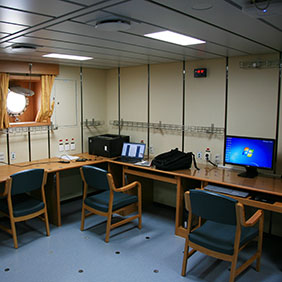
A general laboratory.

A laboratory for collecting and studying clean seawater.

A calibration laboratory.
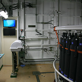
A room for storing CTDs.

A biochemical laboratory.
A geological laboratory.

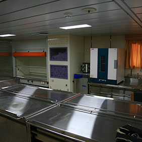
This is where large research equipment and facilities are maintained and repaired and collected samples are pre-treated.

R/V IsabuAccommodation Facilities
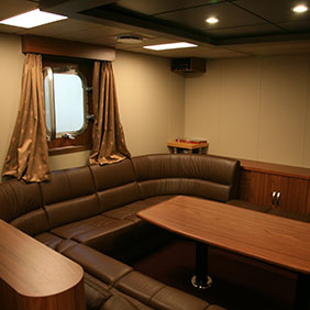
A room where people get together while the vessel is at sea to take breaks, talk together, or hold meetings or events intended to promote unity among the personnel who operate the research equipment aboard the vessel.
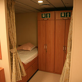
Accommodations for researchers on the vessel.

Accommodations for the vessel’s crew.

An office that dispenses medication and medical supplies and equipment.
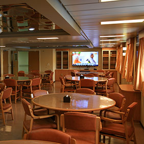
The room where the researchers and crew have meals.
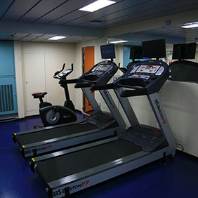
A room where the researchers and crew can get regular exercise so as to maintain good health while on the vessel.

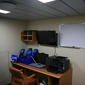
The room where researchers and crew hold meetings and conferences to share preliminary research plans and exploration-related information.

A room equipped with a washer and dryer where the crew can do their laundry while the vessel is at sea.

A room where the researchers and crew can relax outside of their working hours.

A room where waste is collected and treated onboard the vessel.

The room from which all networked systems on the vessel are controlled and managed.
A printing room.
Research Vessel


- Content Manager :
- Last Update : 2022-09-05